IM2GPS: Estimating Geographic Information from a Single Image
| James Hays | Alexei A. Efros |
Proceedings of the IEEE Conf.
on Computer Vision and Pattern Recognition (2008)
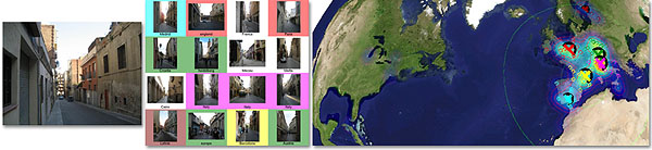
Estimating geographic information from an image is an excellent, difficult high-level computer vision problem whose time has come. The emergence of vast amounts of geographically-calibrated image data is a great reason for computer vision to start looking globally — on the scale of the entire planet! In this paper, we propose a simple algorithm for estimating a distribution over geographic locations from a single image using a purely data-driven scene matching approach. For this task, we will leverage a dataset of over 6 million GPS-tagged images from the Internet. We represent the estimated image location as a probability distribution over the Earth's surface. We quantitatively evaluate our approach in several geolocation tasks and demonstrate encouraging performance (up to 30 times better than chance). We show that geolocation estimates can provide the basis for numerous other image understanding tasks such as population density estimation, land cover estimation or urban/rural classification.
James Hays, Alexei A. Efros (2008). IM2GPS: Estimating Geographic Information from a Single Image. Proceedings of the IEEE Conf. on Computer Vision and Pattern Recognition.
@inproceedings{Hays:2008:im2gps,
Author = {James Hays and Alexei A. Efros},
Title = {IM2GPS: Estimating Geographic Information from a Single Image},
Booktitle = {Proceedings of the IEEE Conf.
on Computer Vision and Pattern Recognition},
Year = {2008},
}
